https://www.americancityandcounty.com/wp-content/themes/acc_child/assets/images/logo/footer-logo.png
  • Home
  • Co-op Solutions
  • Hybrid Work
  • Commentaries
  • News
  • In-Depth
  • Multimedia
    • Back
    • Podcast
    • Latest videos
    • Product Guides
  • Resources & Events
    • Back
    • Resources
    • Webinars
    • White Papers
    • IWCE 2022
    • How to Contribute
    • Municipal Cost Index – Archive
    • Equipment Watch Page
    • American City & County Awards
  • About Us
    • Back
    • About Us
    • Contact Us
    • Advertise
    • Cookie Policy
    • Privacy Statement
    • Terms of Service
American City and County
  • NEWSLETTER
  • Home
  • Co-op Solutions
  • Hybrid Work
  • Commentaries
  • News
  • In-Depth
  • Multimedia
    • Back
    • Podcasts
    • Latest videos
    • Product Guides
  • Resources/Events
    • Back
    • Webinars
    • White Papers/eBooks
    • IWCE 2022
    • How to Contribute
    • American City & County Awards
    • Municipal Cost Index
    • Equipment Watch Page
  • About Us
    • Back
    • About Us
    • Contact Us
    • Advertise
    • Cookie Policy
    • Privacy Stament
    • Terms of Service
  • newsletter
  • Administration
  • Economy & Finance
  • Procurement
  • Public Safety
  • Public Works & Utilities
  • Smart Cities & Technology
  • Magazine
acc.com

Smart Cities & Technology


GIS comes to the rescue
GIS comes to the rescue

States and local governments are using geographic information systems in novel ways for disaster preparedness and response.
  • Written by Gail Short
  • 13th July 2011

States and local governments are using geographic information systems (GIS) in novel ways for disaster preparedness and response. Officials say the technology’s flexibility lets them create tailor-made tools to deal with calamities.

As East Coast and Gulf Coast communities brace for hurricane season, officials in Miami-Dade County are ready to use their new GIS application that lets them quickly map and locate employees during emergencies. The employee locator is a pilot project of the county’s Enterprise Technology Services Department (ETSD), General Services Administration and Department of Solid Waste that began last fall. Users can search by employees’ names, identification numbers, job titles and zip codes to quickly contact the employees who can respond the fastest to a crisis. “The ability to just go into the system and with a couple of clicks identify an individual who can be dispatched to a particular location because he lives close to it is enormously valuable,” says Jerry Hall, Miami-Dade’s division director of Facilities and Utilities Management. “When you’re able to do that, you can respond in less time, and you may save a situation before it gets out of hand.”

Speed also is the focus of the Virginia Department of Emergency Management’s (VDEM) innovative GIS-based platform called Virginia Interoperability Picture for Emergency Response (VIPER), which launched in 2008. VIPER contains static data — such as the location of schools, homes, hospitals and roads — and more than 100 live data feeds from sources including the National Weather Service, the Department of Transportation, the 911 system and satellites. With the combination of static and live data, officials can go to one source to get details about conditions on the ground in real time, says Michael Nelson, VDEM’s deputy director of operations.

VIPER’s usefulness was demonstrated in April when tornadoes ripped through the state. Instead of having to gather reports from five different National Weather Service offices, Nelson says, VDEM staffers captured weather information through VIPER and quickly notified emergency officials hours ahead of time about more impending storms.

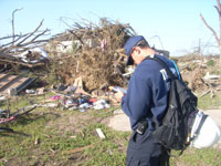
In Tennessee, following an April 27 tornado, Hamilton County’s GIS professionals launched a project to gather tornado damage reports from residents online so the GIS department could map the destruction. About 300 residents responded, entering their addresses and the type of storm damage they experienced, says GIS Manager Greg Butler. Chief of Emergency Management Bill Tittle says the website helped his staff gather damage reports from the more isolated parts of the county.

Tittle encourages emergency officials to work closely with GIS departments. “GIS professionals have so much data,” he says. “They’re creative, and they can generate the maps we use by what we tell them. They’ve done it so much now that they can anticipate what we’re going to ask.”

Related Stories

  • Video: Tornado-struck Joplin, Mo., declared federal disaster zone
  • Mapping The Big One: GIS/GPS helps pinpoint seismic trouble spots
  • Northridge disaster tests GIS workstations
Tags: Public Safety Smart Cities & Technology

Most Recent


  • These 10 American cities are well prepared for a tech-based future
    From smart devices to electric vehicles, the success of technological advancements rely on municipal grids and infrastructure. Some cities are better equipped for the future than others. A new analysis from the tech company ProptechOS ranks the top 10 American cities best positioned for a “smart city future.” “But new technologies can only support us […]
  • public health
    How public health can build a “one health” infrastructure for the future
    Public health challenges—like antibiotic resistance, vector-borne disease and a global pandemic—have eluded traditional public health tools and frameworks. As a result, public health leaders focus more and more on the intersection between the environment and human health. Searching for a better framework to understand emerging threats to human health, many in public health circles have […]
  • Report: With increasing popularity of e-bikes and e-scooters, there's a need for 'safe and connected infrastructure'
    Electric scooters and e-bikes are rising in popularity. As transportation options diversify, local policymakers are beginning to integrate micromobility means as integral fixtures in transportation networks and climate action plans, given their health and climate benefits. But along with solutions, they’re also bringing with them a slew of hurdles. A report out of Oregon highlights […]
  • How 5G is making cities safer, smarter, and more efficient
    This article first appeared on Urgent Communication. It’s a scenario we’ve all experienced: an ambulance with a blaring siren racing against time to get a person in medical distress to a hospital through traffic. What we don’t see is 5G connectivity enabling paramedics to communicate with hospital staff via video conference and coordinate care in […]

Leave a comment Cancel reply

-or-

Log in with your American City and County account

Alternatively, post a comment by completing the form below:

Your email address will not be published. Required fields are marked *

Related Content

  • North Texas alliance partners with Marketplace.city on smart government solutions
  • Harris County deploys next-generation security in 150 public buildings
  • Prioritizing rapid restore leads to stronger ransomware attack recovery
  • Today’s infrastructure needs greater than roads and bridges - It’s time to face our digital connectiveness

White papers


Modernizing government services for today’s resident expectations

24th January 2023

Preparing Your Community Now for the Next Generation of Older Adults

18th October 2022

Helping Government Fleets Achieve Their Goals

30th September 2022
view all

Webinars


How To: Evaluate Digital Government Service Delivery Technologies

23rd January 2023

Using Technology to Enhance Communications

29th November 2022

Learn the benefits of transforming and automating your Contract Management process

4th November 2022
view all

PODCAST


Young Leaders Episode 4 – Cyril Jefferson – City Councilman, High Point, North Carolina

13th October 2020

Young Leaders Episode 3 – Shannon Hardin – City Council President, Columbus, Ohio

27th July 2020

Young Leaders Episode 2 – Christian Williams – Development Services Planner, Goodyear, Ariz.

1st July 2020
view all

GALLERIES


These 10 American cities are well prepared for a tech-based future

1st February 2023

Report: While remote work is causing offices to empty out, walkable cities are still in high demand

26th January 2023

10 American cities with a great downtown

24th January 2023
view all

Twitter


AmerCityCounty

Amid spike, federal transportation department launches initiative to curb traffic-related deaths dlvr.it/Shvs31

3rd February 2023
AmerCityCounty

Engaging businesses to strengthen your community dlvr.it/ShvZn0

3rd February 2023
AmerCityCounty

Report: Some public employees face financial hardship; comprehensive pay packages proved ‘a pathway toward economic… twitter.com/i/web/status/1…

2nd February 2023
AmerCityCounty

Strategic Budgeting for Modern Government dlvr.it/ShrHmD

2nd February 2023
AmerCityCounty

These 10 American cities are well prepared for a tech-based future dlvr.it/Shp7sH

1st February 2023
AmerCityCounty

How public health can build a “one health” infrastructure for the future dlvr.it/ShnlKm

1st February 2023
AmerCityCounty

Four Steps to Better Municipal Fleet Fuel Purchasing dlvr.it/ShnbWP

1st February 2023
AmerCityCounty

Report: With increase popularity of e-bikes and e-scooters, there’s a need for ‘safe and connected infrastructure’ dlvr.it/ShlKmJ

31st January 2023

Newsletters

Sign up for American City & County’s newsletters to receive regular news and information updates about local governments.

Resale Insights Dashboard

The Resale Insights Dashboard provides model-level data for the entire used equipment market to help you save time and money.

Municipal Cost Index

Updated monthly since 1978, our exclusive Municipal Cost Index shows the effects of inflation on the cost of providing municipal services

Media Kit and Advertising

Want to reach our digital audience? Learn more here.

DISCOVER MORE FROM INFORMA TECH

  • IWCE’s Urgent Communications
  • IWCE Expo

WORKING WITH US

  • About Us
  • Contact Us

FOLLOW American City and County ON SOCIAL

  • Privacy
  • CCPA: “Do Not Sell My Data”
  • Cookie Policy
  • Terms
Copyright © 2023 Informa PLC. Informa PLC is registered in England and Wales with company number 8860726 whose registered and Head office is 5 Howick Place, London, SW1P 1WG.