GPS Receiver Displays Maps and Aerial Images
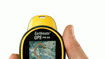
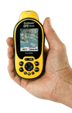 Hand-held Earthmate GPS (Global Positioning System), Model PN-20, includes Windows-based mapping software. Displays maps of the world, streets, specific regions, and other areas, as well as black-and-white aerial imagery and colorized satellite images. Measures about 2.5 ins. wide, 5.25 ins. high, and 1.5 ins. deep; weighs 5 oz. High-resolution, color screen remains visible in direct sunlight and other lighting conditions. Pinpoints trails, structures, waterways, and other landmarks. Provides automatic trail routing, plus doubles as an in-vehicle navigation device. Audible signal warns user of upcoming turns on roads or trails. Waterproof, rubberized housing withstands rugged, outdoor use. Internal flash memory has 75-Mb. capacity. Built-in card slot enables up to 2 Gb. of additional memory. DeLorme, Yarmouth, ME


