Nuclear gauge reads, then transmits moisture and density content
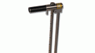
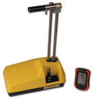 Enhanced RoadReader Plus (Model 3451) nuclear moisture density gauge measures moisture and density of soil, aggregate, asphalt, and concrete in addition to offering an onboard Global Positioning System (GPS) and a wireless Personal Digital Assistant (PDA) user interface. Features 3 modes (soil, asphalt, and thin layer) that measure from 2 ins. to 12 ins. by direct transmission or 1 in. to 4 ins. using the backscatter method. Moisture can be read to maximum depth of 11 ins. from surface of test material. Wireless transmitter resident on the gauge automatically sends the exact GPS location (x and y coordinates) within 3 m., date/time stamp, corresponding measurements, and additional notes to the wireless PDA for each reading, and stores data in gauge memory. Location and readings are encrypted to ensure security and data integrity. Data can be downloaded into encrypted format or sent to MS Excel spreadsheet for sorting and processing. GPS coordinates can be entered into mapping program such as MapQuest or into local DoTs mapping system or GPS-based inventory. Wireless PDA runs on Microsoft CE platform with RoadReader Plus program and Setup Wizard. Gauge runs on NiMH rechargeable batteries that provide 2 to 4 weeks of service at typical usage levels. Batteries fully charge in 2 hrs.
Troxler Electronic Laboratories, Inc., Research Triangle Park, NC