Courtesy of Kenton County, Ky.
Article
Kenton County among first to procure 3-D hydrography data, employ semiautomated remote sensing techniques
If a picture is worth a thousand words, I always say, then a map is worth a million. This explains how the Kenton County (Ky.) Geographic information system and mapping (GIS) has been able to give Northern Kentucky solid direction over the last 35 years. Since its inception in 1985, the department, on its own and through regional partnerships, has leveraged geospatial technologies to best support solution-based decisions throughout the county, the region and the state.
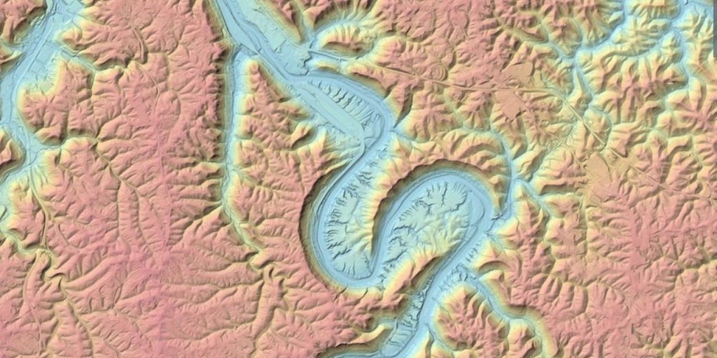
Most recently, this approach led Kenton County to be one of the first municipalities to procure 3-D hydrography data per updated United States Geological Survey (USGS) guidelines that support the 3-D Hydrography Program (3DHP). 3DHP is an emerging USGS initiative designed to gather the most up-to-date hydrography data across the nation to support national- and regional-level issues like flooding, water quality and water quantity. As part of this project, Kenton County also agreed to the application of semiautomated remote sensing technologies to process these data and contribute to the progression of these technologies.
These hydrography data were acquired via a LINK-GIS contract with Woolpert and will be used to map and model the drainage network in this rapidly developing urban area. They will help address stormwater drainage, which is a vital piece of the built environment puzzle, and will be used to model flood control, flood delineation and mitigation, providing a sizable step forward in risk management for Northern Kentucky counties, cities and watersheds.
An innovative history
Kenton County is the third most populated county in Kentucky, located just across the Ohio River from Cincinnati. This region’s rich and collaborative GIS history began with the establishment of the LINK-GIS Partnership in 1985. Originally an environmental cleanup tool for a governmental agency, LINK-GIS has evolved to become a citizen-focused mapping, data and information service for local governments and agencies throughout Northern Kentucky.
The county’s early adoption of GIS is linked to a hepatitis outbreak in the early 1980s that originated from a child playing in what turned out to be a sewage puddle. Attempts to trace the outbreak through the infrastructure using paper maps and outdated documentation greatly delayed solving the issue and extended the outbreak. This made residents and officials throughout the region understand the value of and need for GIS.
GIS creates a repository of historic and evolving location-based data that supports infrastructure across urban, suburban and rural populations and economies. Employing multiple partnerships helps share relevant data, as Kenton County has done, and enables municipalities to take advantage of economies of scale. Geospatial datasets generated from one contract can support the planning and development needs of dozens of municipalities, universities, businesses, police departments, health districts, fire districts, school districts, water and sanitation districts, etc.
The 3-D hydrography data from the LINK-GIS contract will benefit public works, zoning, emergency management and dispatch, impervious surface monitoring, floodplain mapping and more throughout Kenton and Campbell counties. These data also will seamlessly align with other data collected per updated USGS guidelines across the country, supporting broader nationwide initiatives.
3-D Hydrography Program
The USGS has been collecting high-quality topographic elevation data through its 3-D Elevation Program (3DEP) since 2014. These data are being used by governments, agencies and initiatives to inform critical decisions made across the nation every day. Currently, the USGS is replacing the National Hydrography Datasets and modernizing hydrography data under 3DHP to align vertically, horizontally and temporally with 3DEP elevation data.
The 3DHP initiative will derive hydrography features from 3DEP data to provide better accounting of the hydrologic cycle by adding connections to groundwater modeling, engineered hydrologic systems and wetlands. 3DHP will provide researchers, engineers and scientists with the data accuracy and attributes needed to model and analyze surface water, including its relationship to the landscape. Like 3DEP, the national hydrography program will provide a broad range of water-related applications to all levels of government. These applications include flood-risk management, infrastructure development, hazards response and mitigation, and many more.
The USGS cites floodplain delineation as the top application for 3DEP data in Kentucky, followed by engineering studies for transportation projects and locating and assessing landslides and sinkholes. Kenton County is bordered by the Ohio River to the north and the Licking River the east. These major tributaries flow through its hilly terrain, making drainage and watershed management vital to the region. Northern Kentucky and southern Ohio also sit on the Kope Formation, which is comprised of about 80 percent shale and 20 percent limestone rocks and soil, making the area increasingly prone to landslides and subsequent underground infrastructure collapse.
In 2020, LINK-GIS contracted with Woolpert to provide digital aerial orthoimagery, lidar, planimetric data and hydrologic data for Kenton and Campbell counties. The data will address and mitigate persistent stormwater management, flooding and landslide stabilization issues common to the extreme terrain of Northern Kentucky by identifying where the water is running and why.
As the environment and climate have evolved, land has shifted, and rivers and streams have carved out new and sometimes destructive paths. High-resolution, 3-D hydrologic data provides the information needed to model and predict the behavior of rivers, streams, watersheds and coastlines to protect people and infrastructure.
Semiautomated remote sensing
As geospatial needs have grown worldwide, the capacity and systems needed to process that deluge of data have struggled to keep pace. Deep learning is a machine learning technique that seeks to teach computers by example, employing artificial neural networks whose architectures contain multiple hidden layers that learn from different features at multiple levels of abstraction.
Remote sensing has historically been conducted by hand using photogrammetry. The data collected for Kenton and Campbell counties was processed by Woolpert using semiautomated remote sensing. This semiautomated process, coupled with traditional quality control, helps train the computer to recognize features and solve problems. Deep learning algorithms that exploit the unknown structure within the input distribution to discover good representations of the features it needs to extract from data to create a decision-ready analysis for the geospatial technician.
The more data the algorithms are fed, the smarter they become. This enables the process to become quicker and more accurate. So just like the collection and application of geospatial data, collaborative partnerships elevate the impact of this technology.
Competitive edge
Kenton County’s procurement of topographic lidar and 3-D hydrologic data, digital orthoimagery and planimetric data not only supports infrastructure management, planning and development in Northern Kentucky, but it helps the region remain competitive.
“Accurate and updated GIS data makes us competitive with cities like Chicago, Phoenix, New York and even our neighbors across the river in Cincinnati,” said Sharmili Reddy, Kenton County’s executive director of Planning and Development Services. “Like everyone right now, we need a qualified workforce. GIS puts the needed data for housing, businesses, zoning, transportation, water resources—you name it—at our fingertips and gives us the competitive edge we need. As the world continues to trend toward automation and location-based data exchange, our strategic investment in GIS will only continue to pay off.”
Kenton County GIS/IT Director Trisha Brush has 25 years of experience managing geospatial technologies that involve GIS, analysis, business processes, permitting systems, utilities, cartography and GPS. She has served as the GIS/IT director for Kenton County since 2002.
Woolpert Senior Vice President Jeff Lovin is a certified photogrammetrist and photogrammetric surveyor who has been with Woolpert for 35 years. He has led and served on multiple national geospatial committees from the American Society for Photogrammetric and Remote Sensing to the National Geospatial Advisory Committee.


