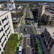
TECHNOLOGY/Radar pinpoints needed road repairs
When work crews make repairs on roadways and bridges, the work often involves tearing up stretches of road, cutting off one or more lanes and delaying traffic for hours or even days. To make repair work more efficient, many transportation departments are using non-destructive ground-penetrating radar (GPR) technology to assess damage before workers dig into the roadway.
“[GPR is] a subsurface investigation and an alternative to drilling,” says Kerry Petrasic, chief geotechnical engineer for PennDOT. “We can isolate the problem to repair the highway.”
Using GPR equipment from Geophysical Survey Systems, North Salem, N.H., PennDOT crews inspect roads, bridges, railroads and other surfaces for damages. The GPR sends a signal through the surface to detect cracks and voids and to survey the general condition of the road. It can check road thickness and locate support rails or utility lines.
Frequently, PennDOT will use the method on a roadway where a problem is suspected. Such was the case when the department recently used GPR to survey roads near old coal mines in Altoona. “There was stress showing in the pavement, indicating voids underneath,” Petrasic says. “We can use [GPR] to better define the area.”
Boston has used GPR techniques on its Central Artery Tunnel project. To create a temporary thruway, New York-based contractor Bechtel/Parsons Brinckerhoff decided to employ two unused bridge decks extending from the Interstate 93 Upper and Lower Decks just north of the city. Because the decks were more than 15 years old, the contractor wanted to survey their condition before putting them to use.
Evaluation with conventional methods would have required workers to remove the asphalt overlay, evaluate the deck and then apply a new temporary overlay. Instead, the company surveyed the decks over two days in December 1998, and the thruway was constructed over the summer to help maintain traffic flow through the city while the existing Upper and Lower Decks are dismantled.