Rosangela Perry/shutterstock
Commentary
Getting ahead of natural disasters: Field-tested planning best practices from San Mateo and Santa Cruz
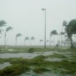
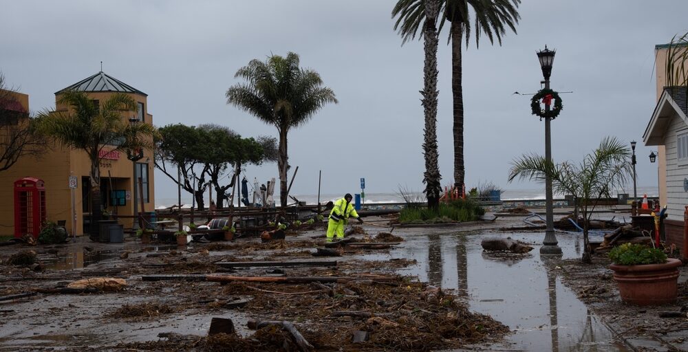
Over 16 days at the beginning of this year, a state of emergency was declared in 51 of California’s 58 counties due to atmospheric rivers and winter storms. From storm surges, mudslides, downed trees, heavy snow, avalanches, power outages and road closures, to river and tributary floods, potential dam spills, as well as urban, residential, and coastline floods—everything was happening everywhere at once. These conditions presented unique challenges for communities, emergency managers and first responders.
After the hazardous conditions had faded and emergency crews could rest, I connected with the two first responders who managed these incidents first hand, Tony Blackman, battalion chief, San Mateo Consolidated Fire Department, and Nick Baldrige, lieutenant, Santa Cruz County Sheriff’s Office, on the lessons learned from the trenches. Below are the combined insights on how emergency teams across the country can get ahead of natural disasters. They include leveraging pre-planned map-based zones and hyperlocal information to protect communities, and managing and coordinating evacuations during prolonged emergencies that require complex collaboration on the ground.
Geo-segment your community
When you’re not actively responding to crises, invest in segmenting your communities into granular response zones. Factor in population data, topology, land use insights, road networks and more, to develop a comprehensive picture of your communities, people and assets. This segmentation, ranging from entire counties to fractions of city blocks or individual properties and facilities, enables emergency managers to quickly identify impacted areas, and communicate specific location details to dispatch centers and to the public through multiple channels. These include social media platforms, community websites, WAZE, and local or national media outlets.
Such granular zones allowed the San Mateo teams to know the exact number and location of residents and critical facilities, like hospitals, senior residences and homes. San Mateo’s first responders then used these zones to identify and address issues with under-a-minute response times. They also dynamically reconfigured the community zones as the crisis made headway to better address the on-the-ground situation, and to automatically update both first responders and the public with contextual alerts.
Another advantage of dividing up neighborhoods into multiple zones is to ensure evacuation orders are sent only to areas where it is necessary, avoiding over-notification and traffic congestion. This is also valuable during repopulation after an incident.
Develop and maintain an active zone-based catalog of critical facilities and infrastructure
An actively maintained catalog provides an instant and accurate snapshot of people and facilities at risk. This catalog is critical for first responders to manage efficient evacuation of residents, while providing one source of truth for all emergency, law-enforcement agencies and first responders within and across jurisdictions. The use of an accurate, zone-based catalog of critical facilities enabled the San Mateo Consolidated Fire Department to swiftly pinpoint the location and distribution of more than 20,000 people and more than 11,800 structures that could require evacuation.
Knowing the location and condition of roads, bridges, tunnels, reservoirs and other infrastructure in each zone is also essential to emergency preparedness and response. San Mateo’s emergency teams continuously tracked which roads remained open and those that were closed due to downed trees or high water. This information helped ensure the public could safely evacuate if needed and enabled first responders to quickly reach the scene. The local utility also used this information to reach and repair downed lines during power outages. During the storms, one of San Mateo County’s three large reservoirs, which serve the city of San Francisco, came within a foot of going over the spillway. By observing reservoir levels and coordinating releases during low tide, the county avoided accidental flooding.
Strengthen your lines of proactive communication
Unless informed by robust pre-planning, managing the deluge of information during emergencies can quickly get out of hand and overwhelm agencies, dispatchers and the public alike. Emergency managers can design pre-scripted alerts for various disasters, such as floods, wildfires, earthquakes, or avalanches. When it is time to activate an alert, managers can leverage their geo-targeted zones to trigger these notifications, in a plug-and-play fashion, to quickly, precisely and efficiently, communicate the right message only to affected residents, visitors and businesses.
This level of preparedness was critical for the seamless coordination among 20 different cities and agencies in San Mateo county. It enabled them to swiftly plan and execute evacuations—with messages and alerts pre-scripted and translated into multiple languages—significantly reducing the time needed to transmit life-saving alerts. In Santa Cruz, emergency teams were able to provide real-time updates and information to the local TV stations, which inserted community updates at the bottom of the screen, communicating accurate and trusted, neighborhood-specific advisories and evacuation information as the crisis unfolded.
Getting ahead of natural disasters: Moving from reactive to proactive preparedness
The escalation of natural disasters around the world, in frequency and severity, calls on emergency managers and first responders to take preparedness measures to a higher level. From wildfires, such as those now affecting Oregon and Washington and many parts of Canada, to our nation’s dams, which now face conditions for which they were not designed, communities must put in place processes and systems that empower a sophisticated, proactive approach to emergency preparedness and response.
While communities across the United States have diverse topography, population and hazards, the principles of preparedness are the same for all 50 states. To delve into more best practices and lessons learned from our leading emergency teams, you can access “Emergency Event Pre-Planning – Response Time from Hours to Minutes” here.
Charlie Crocker is the senior vice president of Saas Products at Genasys (NASDAQ: GNSS), responsible for scaling Genasys Protect, the most comprehensive portfolio of preparedness, response, and analytics software and systems.