Mapping Receiver Pictures and Pinpoints Geographic Locations
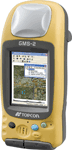 Hand-held GMS-2, a mobile receiver, simplifies and expedites a variety of mapping and surveying tasks in the field. Integrates GPS (global positioning system) coordinates with GIS (geographic information system) attributes, plus offers dual-constellation tracking. Built-in digital camera lets user record visual details of a job site to link photos with locations. Receiver also features electronic compass for displaying directions, as well as a color touchscreen for accessing information. Accuracy levels range from sub-meter to centimeter range. Runs on Windows CE operating system. Equipped with powerful Intel processor, wireless Bluetooth connectivity, and rechargeable lithium-ion battery. Options range from a beacon receiver to various software programs. Topcon Positioning Systems, Inc., Livermore, CA